


MapCircle
Descrição de MapCircle
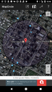
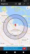
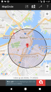
MapCircle is a simple app that allows you to visualize distances by displaying a map with an overlaid circle or donut of a specified radius.
The circle view is useful when you want to see everything that's less than some specified distance from some location.
The donut view is useful when you know that something is "a mile away" (or some other distance), but aren't sure exactly WHERE it is & want to try and guess its likely location. The donut itself represents the region of uncertainty and margin of error.
Features:
* Distance in Miles and Kilometers
* Easily toggle between regular and hybrid map views (hybrid is aerial/satellite image with overlaid map)
* Two visualization types: circle and donut
MapCircle é um aplicativo simples que permite visualizar as distâncias por exibir um mapa com um círculo sobreposta ou de rosca de um raio específico.
A visão círculo é útil quando você quiser ver tudo o que é menos do que a alguma distância especificada de algum local.
A visão de donut é útil quando você sabe que algo é "uma milha de distância" (ou alguma outra distância), mas não tem certeza exatamente onde ele está e quer tentar adivinhar a sua localização provável. O donut em si representa a região de incerteza e margem de erro.
Características:
* Distância em milhas e quilômetros
* Facilmente alternar entre pontos de vista regular e híbrida de mapa (híbrido é aerial image / satélite com mapa sobreposto)
* Dois tipos de visualização: Círculo e filhós
MapCircle - Versão 1.05
(20-01-2020)MapCircle - Informação APK
Versão APK: 1.05Pacote: software.pantherkitty.mapcircleÚltima Versão de MapCircle


Apps na mesma categoria


